

3rd generation BeiDou (BeiDou-3)
Since its establishment in 2006, the Slovak real-time positioning service has provided corrections for the GPS (Global Positioning System) and GLONASS (Globalnaya Navigazionnaya Sputnikovaya Sistema) satellite systems. Subsequently, in 2018, the service was expanded to include the European Galileo system and the Chinese BeiDou system. The latter has undergone the most significant technological evolution in recent years, with the addition of a completely new architecture of 3rd generation BeiDou satellites (BeiDou-3) in 2020. Between 2022 and 2024, the SKPOS reference stations have had their receivers replaced and the SKPOS control software upgraded several times. Following these modifications, the distribution (provision) of corrections from the BeiDou-3 satellites at following mountpoints began on May 13, 2024:
- SKPOS_CM_32
- SKPOS_CM_32_MSM7
- SKPOS_CM_CMRx
The BeiDou satellite system is a Chinese government-developed and operated program. Initially developed to provide precise positioning, navigation and timing services to users in China and surrounding regions. Currently operating worldwide by transmitting signals on five different frequencies similar to other GNSS signals, including those of GPS, GLONASS and Galileo. This ensures that devices compatible with any of these systems can also receive BeiDou-3 signals. The BeiDou-3 signals include two older signals, referred to as B1I and B3I, which were utilized in the previous BeiDou-2 regional system, and three new signals, B1C, B2a and B2b. These new signals operate on the same frequencies as the GPS (L-signals) and Galileo (E-signals) signals. Specifically, the B1C signal is compatible with the L1 and E1 signals, the B2a signal is compatible with the L5 and E5a signals, and the B2b signal is compatible with the L5 and E5b signals.
Advantages of the BeiDou-3 system:
- More satellites available: With a larger number of satellites in its constellation, the BeiDou-3 system ensures better coverage and availability, enhancing the reliability and accuracy of positioning and navigation services globally.
- Lower PDOP values: Position Dilution of Precision (PDOP) values are a measure of the geometry of satellite positions relative to the receiver. Lower PDOP values indicate better satellite geometry, leading to higher accuracy in position determination.
- More stable fixed solution in situations where the sky is partially obscured: The robust satellite network of BeiDou-3 provides more stable and reliable positioning solutions, especially in environments where the sky is partially obscured by obstacles such as buildings, trees, or mountains.
Disadvantages of the BeiDou-3 system:
- Higher data transfer volumes: The larger volume of transmitted data can cause issues with unstable internet connections.
- Increase in initialization time: The system takes slightly longer to initialize due to the greater amount of data being processed during initial solution.
Beidou-3 in SKPOS benchmark test
Prior to incorporating Beidou-3 into the SKPOS service, the Geodetic and Cartographic Institute Bratislava conducted a series of tests to assess the reliability and performance of the Beidou-3 system. Two distinct tests were conducted: the National Spatial Network (Štátna priestorová sieť; SPS) point test and the 24-hour continuous measurement test.
National Spatial Network Point Test
The objective of the initial assessment was to assess the availability of the BeiDou-3 system's signal and to evaluate the accuracy of spatial positioning under varying conditions. The test measurement was conducted at points of the SPS class C in the western region of Slovakia (see figure below). The test measurements were purposely located in areas with varying distances from the nearest reference station, at different altitudes and under different conditions in order to simulate the effects of horizon obscuration. A total of 30 SPS points were subjected to measurement.
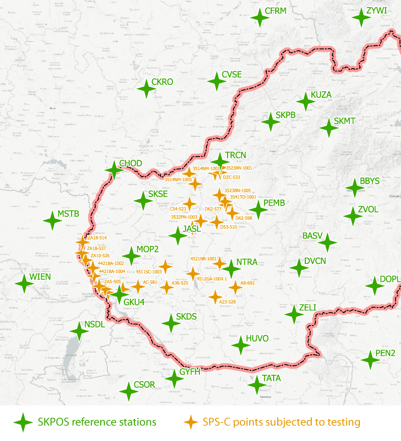
All measurements were conducted in accordance with the guidelines for geodetic measurements using the SKPOS, Two observations were conducted at each point, initially excluding BeiDou-3 satellites and subsequently including them. Each observation was conducted over a two-minute period, with a recording interval of one second and a separation of 20 minutes between each observation. In both cases, corrections were received in the RTCM 3.4 MSM5 format. The measurements were conducted under both optimal and suboptimal conditions, including instances where taller vegetation obstructed the sky. A comparative analysis of the test results obtained for the SPS points can be found in the table below.
| without BeiDou-3 | with BeiDou-3 | |
|---|---|---|
| Average time required for initialization | 10 s | 11 s |
| Average amount of satellites | 23 | 30 |
| Average PDOP | 1.2 | 1.0 |
| Average horizontal deviation | 18 mm | 17 mm |
| Average vertical deviation | 31 mm | 23 mm |
| Maximum horizontal deviation | 47 mm | 40 mm |
| Maximum vertical deviation | 109 mm | 79 mm |
The tests have demonstrated that the incorporation of the BeiDou-3 satellite system within SKPOS led to an increase of seven additional satellites on average, thereby increasing the total average from 23 to 30 satellites. Consequently, the time required for the initialization increased on average by one second, due to the increased number of available satellites. Upon analysis of the spatial coordinates of the individual SPS points, incorporating the BeiDou-3 system exhibited reduced deviations from the reference coordinates of the SPS points. Nevertheless, given the minimal disparity in the observed deviations, it can be concluded that the utilization of BeiDou-3 does not significantly enhance the accuracy of spatial positioning.
24-hour continuous measurements
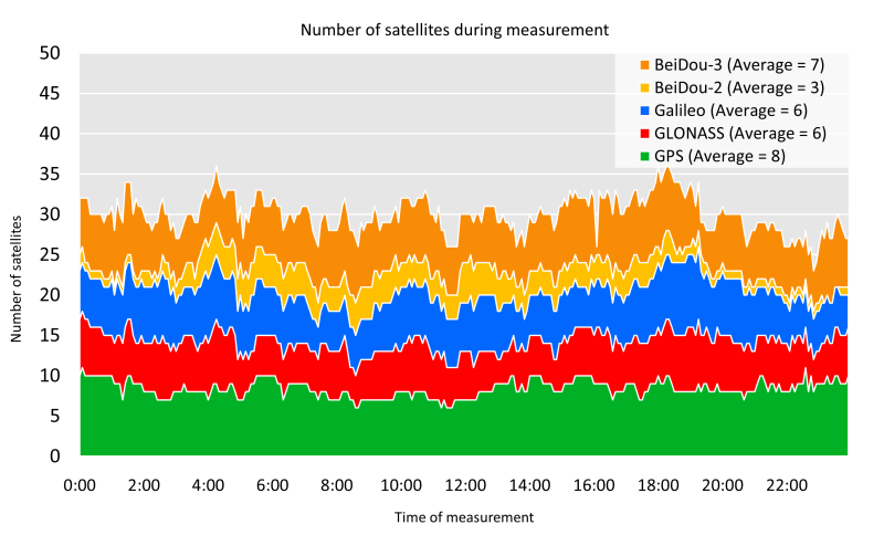
The second test was designed to compare quality parameters during a continuous 24-hour RTN (Real Time Network) measurement without and with the BeiDou-3 system. The test consisted of positioning two identical GNSS receivers approximately one meter apart. During the 24-hour continuous measurement, we compare the number of fixed satellites, the DOP parameters and the deviations from the mean position as observed by the receivers. The figure below illustrates the number of fixed satellites, i.e., the satellites used to compute the resulting spatial position. However, the receiver detects a greater number of satellites, though not all of them are included in the processing.
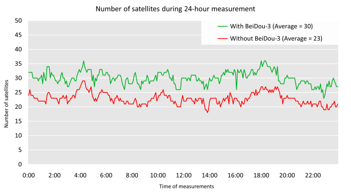
A comparison of the two measurements reveals an increase in the number of satellites when the BeiDou-3 system is employed. The mean number of satellites observed over the entire measurement period without the BeiDou-3 system was 23, while the average number of satellites observed including the BeiDou-3 system was 30. As illustrated in the accompanying figure, the average number of satellites observed for the BeiDou-2 system was 3, while that for the BeiDou-3 system was 7.
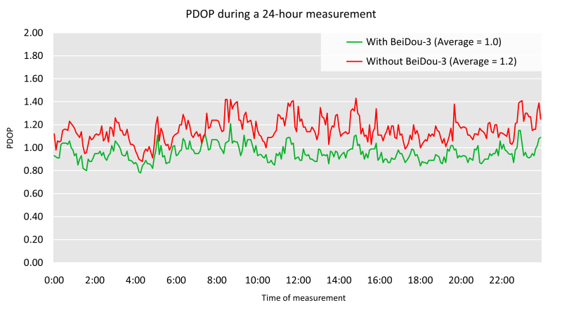
Another qualitative parameter that reflects the quality of GNSS measurements is the spatial position reduction factor (PDOP). This is a numerical characteristic of the quality of the satellite configuration at the time of measurement. A smaller value indicates superior satellite positioning, which in turn yields more accurate measurement outcomes. The figure below illustrates the results of the PDOP values attained during the 24-hour test measurement. The data indicates that the PDOP values are, on average, 0.2 lower when the BeiDou-3 system is employed than when it is not. This is likely due to the higher number of satellites utilized by the BeiDou-3 system.
The final qualitative parameter to be investigated was the standard deviation of the coordinates. The results demonstrated that the standard deviations obtained when utilizing the BeiDou-3 system were virtually identical to those obtained in the absence of this system. The difference in the standard deviations of the horizontal position was approximately 0.02 mm, while in the vertical position it was approximately 0.6 mm. The low values of the differences obtained and the very similar distribution of outliers of the two measurements indicate that the contribution of the BeiDou-3 system to the determination of spatial position is not significant.
Further details regarding the integration of BeiDou-3 into SKPOS can be accessed at:- Testing the benefit of third generation BeiDou in SKPOS - Bachelor thesis