

Slovak real-time positioning service (SKPOS) is a multifunctional tool for precise object and phenomena positioning by global navigational satellite systems (GNSS). SKPOS consists of the GNSS network of permanent reference stations connected by a private virtual network to the National Service Centre established at the Geodetic and Cartographic Institute in Bratislava (GKU Bratislava). The National Service Centre is equipped with the service control software, which administers satellite observations from the permanent stations network and simultaneously generates so-called network corrections for the users of the real-time service and data serving for post-processing for users equipped with post-processing software.
At present, SKPOS represents the most widely used service of the Geodetic Control Department of GKU Bratislava, available to its users 24 hours a day. With its permanent GNSS reference stations infrastructure, represents active geodetic control of Slovakia and most of its points constitute the highest A class of the National Spatial Network points. The service enables to the users to work on-line (real-time kinematic method using a network solution) or in a post-processing way in mandatory geodetic reference systems ETRS89 and S-JTSK (in JTSK03 frame). In case of interest in the coordinates of JTSK frame it is recommended to use freely available official transformation service or software supporting the conversion of coordinates on the basis of a released JTSK03 ↔ JTSK interpolation table.
Legislation
In accordance with the Act No. 215/1995 Coll. of the National Council of the Slovak Republic on Geodesy and Cartography as amended by later regulations (215/1995 Act), a permanent location service, which uses global navigation satellite systems, represents the network of cooperating stations processing and providing real-time geocentric coordinates in real time for the precise location of objects and phenomena. Under §4 point 2n of the Act 215/1995, the task of the Geodesy, Cartography and Cadastre Authority of the Slovak Republic (UGKK SR) is to provide the creation and operation of the permanent positioning service using global navigation satellite systems. UGKK SR, by UGKK SR No. 300/2009 Coll. Regulation, implementing the Act 215/1995 (hereinafter referred to as 300/2009 UGKK SR Regulation), has charged with this task its organization, GKU Bratislava. GKU Bratislava as a legal entity established by UGKK SR under the UGKK SR 300/2009 Regulation provides, administers and operates the Slovak Spatial Observation Service (SKPOS) as a permanent positioning service. Under §3 point 2 of UGKK SR No. 300/2009 Regulation, SKPOS represents active geodetic control of SR, to which the results of all selected geodetic and cartographic activities included in state documentation and submitted to mandatory geodetic reference systems are mandatorily related.
Guideline: Usage of Slovak real-time determination system for surveying
Real-time Kinematic Method – RTK
Real-time Network – RTN
Real-time kinematic method (RTK) requires equipment consisting of one reference non-moving receiver referred to also as a base and the other moving receiver referred to as a rover. Both receivers have to carry out phase measurements to the GNSS satellites simultaneously. Between the receivers continual radio or internet connection must be working by which the transmission of measured data from the base to the rover is provided. The rover has to have inbuilt software for phase measurement processing, on the basis of which it is immediately after initialization able to, both from the received measurements and from the measurements of its own, create differences and to compute a relative position in relation to the base position. However, it is necessary to keep in mind the fact that the RTK accuracy decreases with increasing distance between the rover and the reference base. The method is reliable with the lengths of baselines up to ca 20 km, on account of different distribution of masses in atmosphere and different conditions between the reference base and the rover. To compensate this drawback the Real-Time Network (RTN) method has been developed. The RTN method uses the network of reference stations distributed in the area of interest in the recommended distance; the stations send their real-time observations to the control centre for processing. Using advanced algorithms, the software in the control centre generates a network solution from the data processed; the solution is transmitted to users via the internet and serves for the computation of differential corrections, which means relative positioning of the rover user.

There are several RTN concepts such as MAX, FKP, VRS, and other concepts. SKPOS service provides to its users corrections in the virtual reference station concept (VRS) and nereast reference station concept. VRS concept is based on generating corrections for VRS station, which is situated near the site of the rover (only a few metres distance). The rover uses and interprets data from VRS in the same way as if these data had originated in the real reference station situated in the rover vicinity. In practice it is carried out in such a way that the user's rover after successful authorization sends its approximate position in the NMEA GGA message form to the SKPOS control centre via the internet. The SKPOS control centre software accepts this position as a location for a new VRS, computes corrections for this VRS and sends them back to the rover in RTCM standard or in some other proprietary format. When the rover receives the corrections, it classifies them as data from the reference station and determines the relative position by the same processing as that used with the RTK method. The rover takes the coordinate system, framework and epoch of the measurement from VRS that is from the SKPOS service setting.
Nereast reference station concept is based on sending corrections directly from the nearest reference station. Network corrections are not generated, but data are sent directly from the nearest reference station. The moving rover, after successful authorization, sends its approximate position in NMEA GGA message to the SKPOS control center via the Internet. Based on this approximate location, the software identifies the nearest reference station and starts sending data directly from that reference station. Due to the different distribution of masses in the atmosphere and the different conditions between the location of the reference station and the moving receiver, the method is reliable up to a distance of 20 km from the reference station. The advantage of the method is that a larger number of satellites are sent than with the VRS method. More information about the concept of the nearest reference station can be found in the tutorial section.
SKPOS Infrastructure
- Reference stations network
- National service centre
- Virtual private network
Reference stations network (reference stations list)
SKPOS represents active geodetic control of Slovakia. Physical geodetic points, on which antennas of SKPOS receivers are mounted, make up the reference stations network of global navigation satellite systems, essential part of which forms the highest class of geodetic control points, i.e. the A class of the National Spatial Network. The network of SKPOS reference stations consists of the reference stations located on the territory of Slovakia, but also of the reference stations located in adjacent foreign countries on the basis of an agreement on data exchange from foreign stations with the neighbouring administrators of national services.
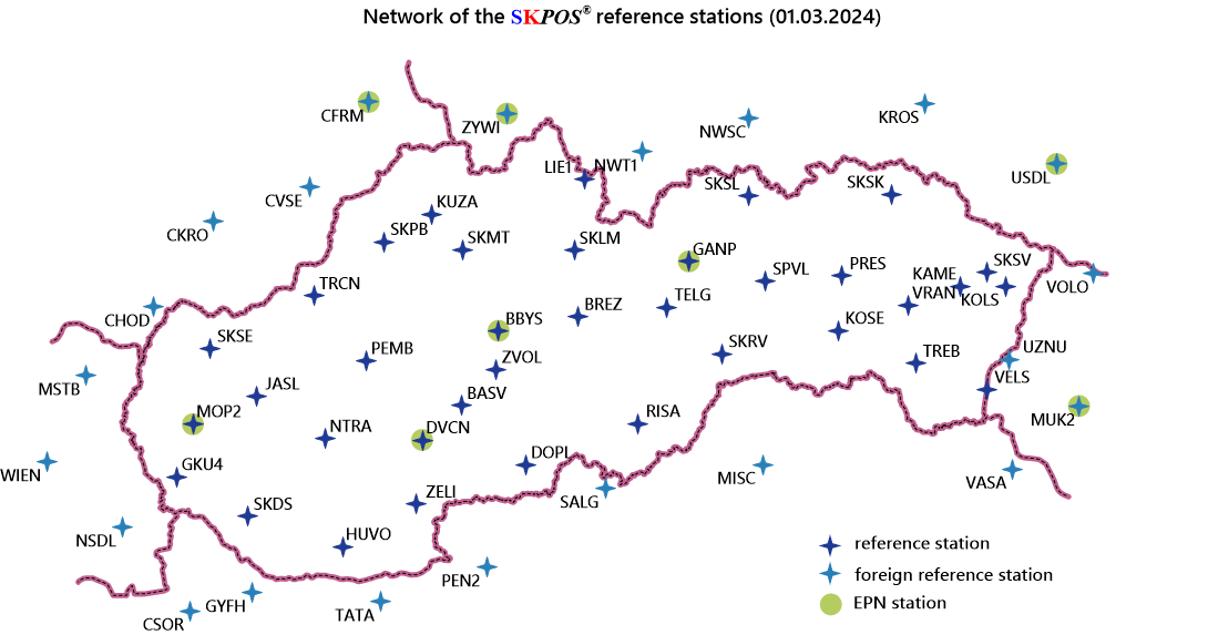
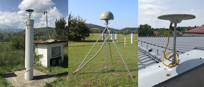
The reference stations located on the territory of Slovakia are established on the supporting parts of the roofs of the buildings of predominantly cadastral departments of district councils, or, as the case may be, they are monumented by a reinforced concrete pillar, or by a special deep drilled braced monument. Positions of the coordinates of reference stations are computed using the scientific Bernese GNSS software. Reference stations located on the territory of Slovakia are also connected by precise levelling to the national level network, which has allowed the determination of their elevations in the Bpv datum. All reference stations located on the territory of Slovakia are equipped with the Trimble brand instruments. 21 antennas have precise position parameters and phase centre variations determined by individual absolute robotic calibration. On other antennas, during computation the values from so-called type absolute calibrations are used.
All reference stations located on the territory of Slovakia receive signals from the GPS, GLONASS, Galileo and BeiDou satellite systems. With regard to the monumentation type, (monumentation by a reinforced concrete pillar, or by a special deep drilled braced monumentation), as many as 22 permanent stations located in Slovakia fulfil also high requirements on the geodynamic research quality; therefore they are incorporated also into the network used for diagnosing deformations of physical earth surface on the territory of Slovakia.
National service centre
National service centre of SKPOS is established at the Geodetic and Cartographic Institute in Bratislava and provides all activities connected with its routine operation and development. The national centre provides the administration of reference stations and their data monitoring, collection and back-up, supervision of the running of the control software that provides generation of corrections for individual services, user registration and contact and monitoring of the quality of services provided. Major part of routine work is provided using the control and processing software, which from the beginning is of the same brand as the infrastructure of the reference stations. In pursuance of the service development the national service centre provides various analyses of the data obtained and stored by the service control software, as well as the creation and administration of applications using the service data. Collaboration with partner foreign positioning services and various international organizations is a matter of course, an also the service promotion and its presentation in professional events and journals.

WPS-WAN virtual private network
As it is necessary to have high-quality and stable communication between SKPOS reference stations and the national service centre, most reference stations are located in the vicinity of the cadastral departments of district councils, which are connected to the UGKK SR virtual private network (VPS). VPS to other reference stations located on the territory of Slovakia is established especially via direct connections. VPS serves for data transmissions from the reference stations to the national service centre and for user internet communication. Foreign stations of partner national positioning services are connected to SKPOS via the external WAN network.

Services and products provided
SKPOS users can choose from three basic services, which differ from each other by the accuracy and form of the data provided.
SKPOS®
for code measurements
for phase measurements
and phase measurements
| Product | SKPOS_dm | SKPOS_cm | SKPOS_mm |
|---|---|---|---|
| Data access | Real-time NTRIP protocol 195.28.70.16:2101 |
Real-time NTRIP protocol 195.28.70.16:2101 |
Post-procesing Web portal http://skposonlineobchod.gku.sk |
| Data format | RTCM 2.1 RTCM 2.3 |
RTCM 2.3, RTCM 3.1 RTCM 3.4, CMRx, CMR+ |
RINEX 2.xx RINEX 3.xx |
| Concept | Virtual reference station (VRS) |
Virtual reference station, nereast reference station |
VRS or the SKPOS station |
| Accuracy | 0,3 – 1 m | 2 – 4 cm | mm – cm |
| Interval of a record | 1 sec. | 1 sec. | 1 – x sec. |
| Typical use | GIS, navigation, transport | Geodesy, cadastre | Very precise measurements |
| Reference system (frame) | ETRS89 (ETRF2000) S-JTSK (JTSK03) |
ETRS89 (ETRF2000) S-JTSK (JTSK03) |
ETRS89 (ETRF2000) |
| Subservice (mountpoint) (datastream) |
SKPOS_DM_SVK SKPOS_DM_SVK_23 |
SKPOS_CM_23 SKPOS_CM_31 SKPOS_CM_32 SKPOS_CM_32_MSM7 SKPOS_CM_NS_34_MSM7 SKPOS_CM_CMRx SKPOS_CM_CMRplus |
|
| Price | 25,- EUR/year | 70,- EUR/year 25,- EUR/month |
70,- EUR/year 3.00,- EUR + 0.07,- EUR/hour |
SKPOS_dm
The service provides differential corrections for real-time code measurements (DGNSS or DGPS) in the virtual reference station (VRS) concept. To use this service it is enough to have a simple and relatively inexpensive GNSS receiver allowing only code measurements, which is able to receive real-time DGNSS corrections. The service delivers decimetre-level accuracy. Correction format RTCM 2.1 and RTCM 2.3. The service is typically used in transport, vehicle navigation and in various geographic information systems (e.g. GIS mapping). Part of SKPOS_cm service are also 50 hours of files for measurement post-processing in RINEX format (service SKPOS_mm) and SKPOS Online Postprocessing service.
SKPOS_cm
The service provides differential corrections for real-time phase measurements (RTK) in the virtual reference station (VRS) concept or nereast reference station concept. To use this service a dual-frequency GNSS receiver is necessary, which is able to process RTK corrections in one of RTCM 2.3, RTCM 3.1, RTCM 3.4, CMRx, CMR+ formats. The service delivers 2 – 4 cm-level accuracy. The service can be used in geodesy, in precise agriculture or in mechanisms guiding. Part of SKPOS_cm service are also 50 hours of files for measurement post-processing in RINEX format (service SKPOS_mm) and SKPOS Online Postprocessing service.
SKPOS_mm
The service makes possible access to data for phase and code measurement post-processing in the virtual reference station (VRS) concept or from the SKPOSstation. Data are accessible to users for an entered time interval in RINEX 2.11 or RINEX 3.02 standard formats through SKPOS data-shop after registration via the SKPOS portal.
| Service | Mountpoint | Data format | GNSS | Data rate | Uses |
|---|---|---|---|---|---|
| SKPOS_dm | SKPOS_DM_SVK | RTCM 2.1 | GPS | 0.1 kB/s | Older RTCM 2 standard, corrections for code GNSS measurements for GPS only. Accuracy in dm. |
| SKPOS_DM_SVK_23 | RTCM 2.3 | GPS, GLO | 0.2 kB/s | older RTCM 2 standard, corrections for code GNSS measurements for GPS and GLONASS. Accuracy in dm. | |
| SKPOS_cm | SKPOS_CM_23 | RTCM 2.3 | GPS, GLO | 0.8 kB/s | Older format, send more data volume. Some older receivers works just with this format. |
| SKPOS_CM_31 | RTCM 3.1 | GPS, GLO | 0.3 kB/s | Use this mountpoint in case of tracking just GPS and GLONASS | |
| SKPOS_CM_32 | RTCM 3.4 MSM5 | GPS, GLO, GAL, BDS | 1.0 kB/s | Use this mountpoint in case of tracking all 4 GNSS | |
| SKPOS_CM_32_MSM7 | RTCM 3.4 MSM7 | GPS, GLO, GAL, BDS | 1.2 kB/s | Include the same data as mountpoint SKPOS_CM_32, but in high resolution. Some newer receivers work just with this format. | |
| SKPOS_CM_NS_34_MSM7 | RTCM 3.4 MSM7 | GPS, GLO, GAL, BDS | 1.4 kB/s | Data directly from the nearest reference station. Suitable for distance up to 20 km from SKPOS reference station. More satellites than the VRS concept. | |
| SKPOS_CM_CMRx | CMRx | GPS, GLO, GAL, BDS | 0.5 kB/s | For Trimble receivers only, corrections for all 4 GNSS. More compressed format and small data volume. | |
| SKPOS_CM_CMRplus | CMR+ | GPS, GLO | 0.3 kB/s | Old Trimble format (for Trimble receivers only), corrections for GPS and GLONASS |
How to order SKPOS
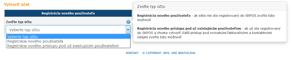
The order of the Slovak Real-Time Positioning Service is made using SKPOS web portal available at: http://www.skpos.gku.sk/register/
Step 1: Fill out the web form according to the instructions. Agree with the General Terms and Conditions for the purchase of SKPOS products and services::- Conditions valid from 01.06.2020
- Conditions valid from 25.05.2018 to 31.05.2020
- Conditions valid from 19.12.2016 to 24.05.2018
- Conditions valid from 14.5.2015 to 18.12.2016
Step 2: After registration by the administrator, an electronic version of the invoice will be sent to the e-mail address you entered, which must be paid by bank transfer.
Step 3: Once the payment is identified, your user account will be activated. We will keep you informed by e-mail about the entire registration process.
Extension of the SKPOS service
The extension of the service is performed by filling in the web form, which is sent to the user by e-mail 30 and 10 days before the end of access and on the day of termination of access. The next procedure is identical to the procedure described in the How to order SKPOS section.
Bezplatné využívanie služby
Na základe zákona NR SR č. 145/1995 Z. z. o správnych poplatkoch a zákona č. 275/2006 Z. z. o informačných systémoch verejnej správy môže Odberateľ, ktorým je rozpočtová organizácia, obec, mesto, mestská časť, alebo VÚC, bezplatne využívať službu SKPOS.
Po registrácii je potrebné zaslať poštou alebo elektronicky (podpísané zaručeným elektronickým podpisom) čestné vyhlásenie o tom, že užívateľ registrovaný na Portáli SKPOS je zamestnancom Odberateľa a že registrácia bude využívaná v zmysle platných všeobecných obchodných podmienok.
Equipment required for SKPOS user
GNSS receiver with ability:- work with RTK/RTN method,
- mobile internet connection (GSM/GPRS/3G/...),
- data reception using the NTRIP protocol and support of some of RTCM 2.1, RTCM 2.3, RTCM 3.1, RTCM 3.4, CMRx, CMR+ formats,
- transmitting position in the NMEA GGA string.
- correct parameters of Bessel ellipsoid:
- length of main semi-axis: 6377397.155 m
- inverse flattening: 299.1528128
- correct parameters of a global transformation key:
- direction of transformation S-JTSK(JTSK03) → ETRS89:
- Translation in the direction of axis X: tx = 485.021 m
- Translation in the direction of axis Y: ty = 169.465 m
- Translation in the direction of axis Z: tz = 483.839 m
- Rotation of axis X: rx = –7.786342"
- Rotation of axis Y: ry = –4.397554"
- Rotation of axis Z: rz = –4.102655"
- Parameter of scale change: m = 0.000000 ppm
- Direction of transformation ETRS89→S-JTSK(JTSK03):
- Translation in the direction of axis X: tx = –485.014055 m
- Translation in the direction of axis Y: ty = –169.473618 m
- Translation in the direction of axis Z: tz = –483.842943 m
- Rotation of axis X: rx = 7.78625453"
- Rotation of axis Y: ry = 4.39770887"
- Rotation of axis Z: rz = 4.10248899"
- Parameter of scale change: m = 0.000000 ppm
- direction of transformation S-JTSK(JTSK03) → ETRS89:
Note. The above-given parameters of the global transformation key are transmitted via RTCM3.x message No. 1021 (using mountpoints SKPOS_CM_31, SKPOS_CM_32, SKPOS_CM_32_MSM7, SKPOS_CM_NS_34_MSM7).
For conversion of S-JTSK coordinates from JTSK03 frame to the JTSK frame it is recommended to use transformation service, or the use of JTSK03 ↔ JTSK interpolation talbe implemented to the GNSS receiver.
For the transfer of ellipsoidal heights from the ETRS89 geodetic reference system to elevations in the Bpv vertical system it is possible to use also the transmitted RTCM3.x message No. 1023 (using mountpoints SKPOS_CM_31, SKPOS_CM_32, SKPOS_CM_32_MSM7, SKPOS_CM_NS_34_MSM7) or using the implementation of Digital Elevation Reference Model (DVRM) to the receiver. Various types of DVRM formats you can download here Geodetic control – for download, or the use of the transformation service is also possible.
User manuals
- Reference Data Shop
- SKPOS Online Postprocesing
- Use of the concept of the nearest reference station
- 3rd generation BeiDou (BeiDou-3)
SKPOS as part of EUPOS
![]() EUPOS (European Position Determination System) is an international non-profit initiative of public institutions mainly from Central and East European countries, providing GNSS services on their territories. Its aim is to facilitate the creation of and support the operation of multifunctional ground-based augmentation systems making GNSS measurements more accurate on unified basis, to act as a European organization representing the voice of public positioning services representatives and to collaborate with scientific and research organizations as well as with international organizations such as RTCM. The Initiative was established in the year 2002 in order to establish GNSS positioning services on the territories of member states, following example of the German service SAPOS, which initiated also the later establishment of SKPOS. Currently EUPOS comprises 14 member states. Positioning services of member organizations (countries) are established and operated on the basis of unified standards, which results in the interoperability of national positioning services and in simple collaboration in data exchange. Slovakia, or GKU Bratislava with the SKPOS service has been from the beginning of the Initiative establishment its integral part, having observed its standards.
EUPOS (European Position Determination System) is an international non-profit initiative of public institutions mainly from Central and East European countries, providing GNSS services on their territories. Its aim is to facilitate the creation of and support the operation of multifunctional ground-based augmentation systems making GNSS measurements more accurate on unified basis, to act as a European organization representing the voice of public positioning services representatives and to collaborate with scientific and research organizations as well as with international organizations such as RTCM. The Initiative was established in the year 2002 in order to establish GNSS positioning services on the territories of member states, following example of the German service SAPOS, which initiated also the later establishment of SKPOS. Currently EUPOS comprises 14 member states. Positioning services of member organizations (countries) are established and operated on the basis of unified standards, which results in the interoperability of national positioning services and in simple collaboration in data exchange. Slovakia, or GKU Bratislava with the SKPOS service has been from the beginning of the Initiative establishment its integral part, having observed its standards.
SKPOS as a part of EPN Densification
 In addition to the SKPOS service operator, GKÚ Bratislava is also an operational centre (OC) of the EUREF permanent network (EPN), which performs routine processing and computation of precise SKPOS station’s coordinates to densify the EPN network in Europe and to implement ETRS89 geodetic datum in Slovakia. Daily and weekly (combined) SKPOS coordinate solutions in SINEX format are calculated weekly using the scientific GNSS software Bernese 5.2 and then sent to EPN Combination Centers where they are combined with other national solutions (the so-called EPN Densification project).